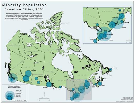
Canadian Minorities by Zachary Johnson 2005
Zachary Forest Johnson is (according to his bio page) a cartographer specializing in online maps and information visualizations. He is in the second year of a M.S. program in Cartography and GIS at the U of Wisconsin. In a previous life, he studied Political Science (gaining a BA from the U of Arkansas and a MA from the U of Wisconsin). His other passions include running, politics, typography, and gin and tonics.
Zachary is also the author of the blog indiemaps.com, an interesting blog on contemporary mapping methods using HTML and Java to produce interactive mapping systems and interfaces, various information on historical figures and news. Based on Zachary’s previous education, as outlined above, a certain geo-political undertone can be felt throughout the work; which is a conceptual framework that is at times hard to take at face value (nor should it be) since it is employing abstract data to map something like a countries extent of “freedom” (see Johnson’s “World Freedom Atlas“).
On Zachary’s blog, there is a very interesting post on “Wild” Bill Bunge aka William Wheeler Bunge Jr. (born 1928, La Crosse, Wisconsin).
Theoretical Geography and the spatial-quantitative revolution
In a 2001 retrospective on the classics of human geography, Kevin Cox wrote that Theoretical Geography is “perhaps the seminal text of the spatial-quantitative revolution” and that (speaking of the broader field of human geography) “if we want to see where we have come from, what our intellectual debts are, there are few better places to start than Theoretical Geography.” Bunge’s work promotes geography as a science and mathematics as the most fruitful language and tool for its study. As the title makes clear, the author was concerned with theory, and believed that simple laws were discoverable about the patterns of social phenomena found on the earth’s surface.
In part, this was a reaction against the idiographic perspective then present in the discipline. Idiographic methods are concerned with describing the infinite variation in these social phenomena rather than discovering generalizable laws common to the entire surface. Bunge thought such an idiographic view would continue to marginalize geography as a science, but received much opposition from geographers who valued the traditional role of description in geographic practice. Later opposition formed against Bunge’s conflation of geometric pattern with explanation; mathematical functions and simple geometric patters couldn’t, in and of themselves, be said to explain anything.
-Taken from indiemaps.com‘s epic post on Bunge
Below are some images also from indiemaps.com of Bunge at work in the Fitzgerald neighbourhood, along with some of his maps of Detroit.
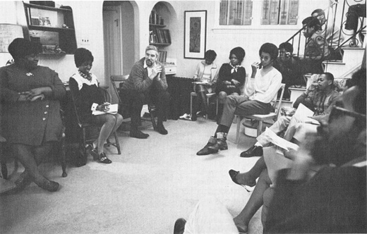
A photo of Bill Bunge at a block club meeting at his home in the Fitzgerald neighborhood of Detroit. He was an active member of the Fitzgerald Community Council and developed deep connections in the neighborhood; this laid the groundwork for the Detroit Geographical Expedition he would later found (more below). Bunge’s association with African American citizens and his anti-war sentiments in the U.S.A. and Canada caused him to be considered a radical geographer.
The works of Bill that I find most compelling and relevant are his work in the series Fitzgerald: Geography of a Revolution and the output of the Detroit Geographic Expedition. Where Bunge created some experimental and inspirational maps about Detroit’s socio-political landscape. Below are a few maps taken from this series.
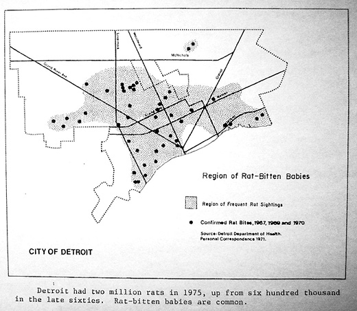
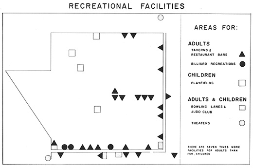
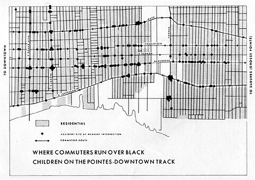
There are a few themes found in these maps that I think are very important, especially for interdisciplinary research groups like Broken City Lab and for communities as a whole. There is an inclusion and focus on groups that exist outside of the age of majority (which in this region is about 21), primarily children. This focus on children and youths highlight the need to value children. In these particular maps, it is a focus on Black and inner city children that creates an alarming perspective on the stark contrast in the quality of life when comparing the many suburbs of Detroit and the realities of it’s downtown core residents. A contemporary version of one of these maps might be the drop-out rate of youths from high-school or the percentage of youths that attend post-secondary institutions, etc.
The socio-political work of Bill Bunge, along with the contemporary mapping processes and technologies of Zachary Johnson are inspiring plateaus to create informative and powerful works with profound resonance. The research of Broken City Lab (for example, the Sites of Apology / Sites Of Hope Project) often encompasses a kind of quantitative geography that allows the aesthetic of scientific thought to intersect with psycho-geographic understandings of your surroundings, which might encompass the emotions, sights or sounds of a certain location; information that is not often found on a map.

Interesting you bring up Bill Bunge. Lee Rodney was just in my Ways of Knowing course last week giving a lecture that included some of his maps, which has also led to some thought towards some other mapping projects that could touch on the same idea you’re talking about here — that is, mapping the things that don’t usually get mapped.
I also just picked up The Map As Art, haven’t even started making my way through it, but it continues to pique my interest in cartography.
My interest in Bill Bunge was also inspired by Lee Rodney in my Border Culture class. Even though we didn’t spend a lot of time on him, I found the few maps she showed us carried a lot of resonance with me.
Since my interest in infographics began in your class I have been exploring the charting and presentation of information in creative ways. I think Bunge will be a large influence in my work later.
Yes, that book looks really interesting. Getting some ideas?